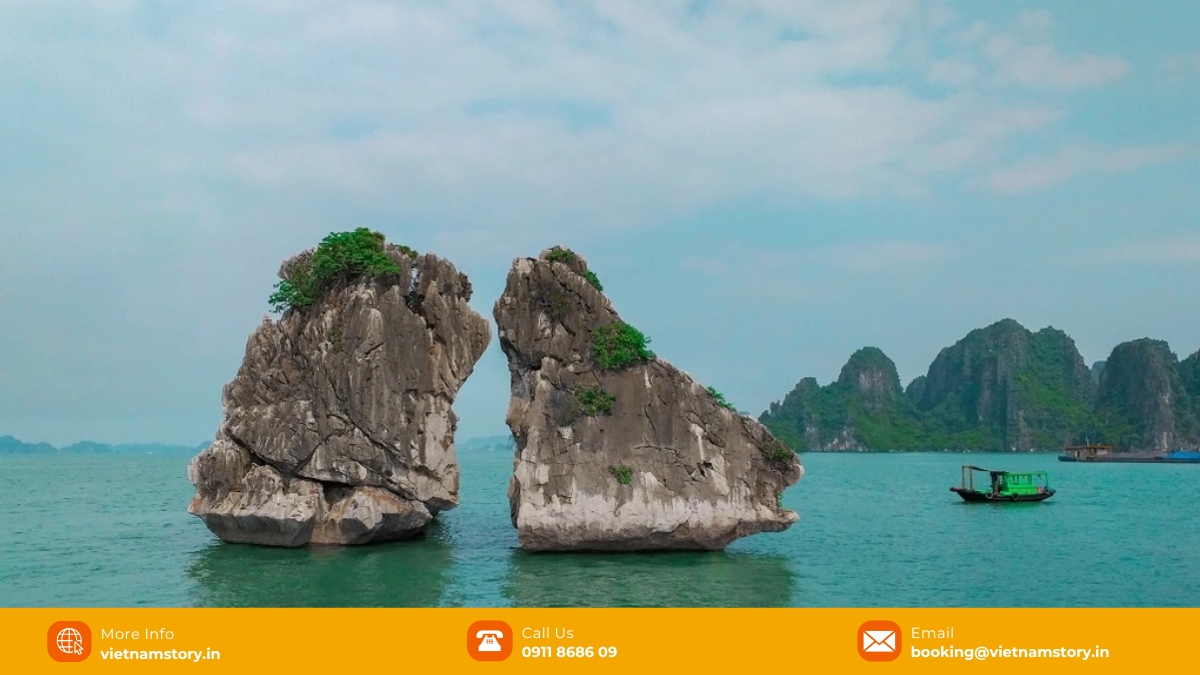
Fighting Cocks Islet is one of the best-known rock silhouettes in Ha Long Bay. The Ha Long Bay Management Department lists it as Hòn Trống Mái (also called Hòn Gà Chọi) and notes that it was selected as a symbol of Ha Long Bay tourism and, in 2000, as a symbol of Vietnam tourism. The formation is made of two small limestone rocks facing each other, commonly compared to a rooster and a hen.
One correction matters: Fighting Cocks Islet is not the landmark printed on Vietnam’s 200,000 VND banknote. That image is Hòn Đỉnh Hương (Incense Burner Islet), another Ha Long landmark. VNS therefore treats Fighting Cocks as an iconic viewing point in its own right rather than borrowing the banknote story from a different islet.

Where is Fighting Cocks Islet, and which routes include it?
Fighting Cocks Islet is a well-known viewing landmark on the classic Ha Long sightseeing circuit. It appears on routes 1 and 5, but travellers should still confirm that their booked itinerary actually passes it.
The Ha Long Bay Management Department places the islet about 5 km from Tuan Chau International Marina and around 7 km from Ha Long International Passenger Port. It is listed on sightseeing routes 1 and 5. That does not mean every cruise passes it: the route on the confirmed booking is what matters.
On Route 1, the same sightseeing circuit also includes landmarks such as Stone Dog Islet and Hòn Đỉnh Hương. The exact order and viewing time depend on the vessel and route operation, so VNS does not present one fixed sequence as universal.
Why the islet needs conservation
The “Fighting Cocks” are visually distinctive limestone rocks with broader upper sections and narrower bases. Quang Ninh authorities have monitored the formation because geological processes, waves, weather and human activity can contribute to instability over time.
Official descriptions put the two rocks at roughly 12–14 metres high: the Ha Long Bay Management Department uses about 12 m, while a Quang Ninh conservation report gives about 13.9 m. The important point for travellers is the paired silhouette, not treating one rounded figure as exact engineering data.

The narrow bases and visible fracture systems are part of the reason the formation has received conservation attention. Official Quang Ninh reporting describes geological and geodynamic processes together with waves, seawater, climate and human activity as factors affecting the islet; VNS does not reduce that risk to one simplified erosion mechanism.
Quang Ninh has studied the risk of rockfall and structural instability at Hòn Trống Mái. In 2023, transport authorities asked vessels passing the area to reduce speed and keep a minimum approach distance as protective measures. These controls are for conservation and safe operation; they should not be turned into a promise of a longer viewing window.
After the vessel passes the islet, look back from the opposite side. The Ha Long Bay Management Department notes that the two rocks can visually merge into the silhouette of a giant fish from this changing angle.
For the current route, symbol and legend information, see the Ha Long Bay Management Department’s Hòn Trống Mái page.
Why the islet has two common names
The formation is commonly called both Hòn Gà Chọi and Hòn Trống Mái. Rather than assigning each name a separate official meaning, VNS uses the legend published by the Ha Long Bay Management Department as the cultural reference.
According to the management authority’s version of the legend, after the Dragon Mother and her children stayed on earth, the Jade Emperor sent a pair of chickens to call them back. A rooster and a hen were sent by mistake; captivated by the landscape and each other, they forgot the mission and turned into stone. This is folklore rather than geological history, but it helps explain why the paired silhouette is remembered as a rooster-and-hen formation.
How to photograph Fighting Cocks Islet from the cruise
The shape changes noticeably as the vessel moves past it. The management authority even notes that, from another perspective after the boat passes, the paired rocks can appear to merge into the silhouette of a giant fish. For photography, the useful advice is therefore simple: stay ready as the viewing angle changes instead of relying on one claimed “best” approach direction.
Lighting depends on season, cloud, haze and the time your booked route reaches the islet. The cruise schedule, weather and viewing direction can all change, so VNS treats photography timing as opportunistic rather than promising a particular lighting window.
If you are a keen photographer, using a polarized filter will help to cut through the glare on the water’s surface. A zoom lens (200mm or more) is also great for isolating the roosters from the other cruise boats that may be in the background.
VNS viewing tips for this brief cruise landmark
At Vietnam Story, we treat this as a simple orientation moment rather than a staged attraction. If the islet matters to you, ask the guide to alert you shortly before the vessel reaches it and move to an open viewing area in time.
- Do not use the 200,000 VND banknote as a match: the landmark printed on that note is Hòn Đỉnh Hương, not this islet. If you want a comparison photo, save the banknote shot for the correct landmark.
- Keep meal timing separate from the landmark: cruise dining schedules vary by vessel. If you do not want to miss the view, tell the guide or crew that you want a warning before the vessel reaches the islet.
- Follow the crew’s viewing instructions: authorities have used speed and approach-distance controls to reduce pressure on the formation, but that does not guarantee a longer viewing window on every sailing.
What else appears on the same classic sightseeing circuit?
Route 1 groups this islet with several other classic Ha Long landmarks. VNS uses the route itself—not invented kilometre estimates—to help travellers understand what may appear on the same sightseeing circuit.
| Landmark | How it relates to this route |
|---|---|
| Hòn Đỉnh Hương (Incense Burner Islet) | Another Route 1 landmark; this is the formation shown on Vietnam’s 200,000 VND banknote. |
| Stone Dog Islet | Also appears on the classic Route 1 sightseeing circuit. |
| Thiên Cung Cave and Đầu Gỗ Cave | Major cave stops associated with Route 1; whether your specific cruise enters one or both depends on the booked programme. |
Use the landmark as one route preference, not as the only reason to choose a cruise; duration, caves, kayaking, swimming and boarding logistics may matter more to the overall trip.
Practical questions before you choose a route
The useful questions are whether your route passes the islet, whether you can land, and what the conservation controls mean for viewing. Those answers are more reliable than treating the landmark as a guaranteed stop on every Ha Long cruise.
- Can you land on the rocks? No. Current conservation reporting says visitors are not allowed onto the islet. Treat it as a viewing landmark from the vessel.
- Is it included on every cruise? No. Official route information places Hòn Trống Mái on routes 1 and 5. Confirm the exact route on your booking instead of using the departure port or cruise category as a guarantee.
- How tall are the rocks? Official sources use slightly different rounded figures, roughly 12–14 metres. That variation is why VNS avoids presenting one rounded number as precision engineering data.
Conclusion
Fighting Cocks Islet is best understood as a brief but recognisable viewing landmark on routes 1 and 5, not as a standalone excursion. Its value comes from the paired limestone silhouette, the local legend and its place in Ha Long’s tourism imagery. If seeing it matters to you, confirm the route before booking rather than assuming every Ha Long cruise passes it.
If Hòn Trống Mái is one of the landmarks you want to see, compare current Ha Long Bay cruise options by route and confirm that the booked itinerary follows route 1 or 5. VNS does not promise a particular viewing distance or timing beyond the operator’s current programme and conservation controls.