
Vietnam, a land celebrated for its vibrant culture, stunning coastlines, and rich history, also boasts a dramatic and diverse mountainous landscape that beckons travellers from India and across the globe. Covering a significant portion of the country, these Vietnamese mountains are far more than just geographical features; they are towering masterpieces offering sublime views, exhilarating adventures, biodiversity hotspots, and cultural havens. From misty peaks perfect for trekking enthusiasts to accessible summits with breathtaking panoramas, the mountains of Vietnam offer something for every kind of explorer looking to escape the city buzz and connect with nature’s grandeur.
Each mountain tells a story, offering unique beauty and natural charm. Whether you seek the challenge of a multi-day trek or the ease of a scenic cable car ride, exploring these peaks is a must. If you wish to seamlessly explore the beauty of these natural wonders, consider adding them to your itinerary with the best Vietnam tour packages designed for an exclusive adventure, particularly appealing for travellers from India seeking unique experiences.

The Majestic Backbone: Understanding Vietnamese Mountains
Vietnam’s mountains are integral to the nation’s identity, profoundly shaping its climate, culture, and appeal as a travel destination. This dramatic landscape, stretching from the Red River Delta to the Mekong, is a product of millions of years of geological activity. More than just visually stunning, these mountains are globally recognized biodiversity hotspots, harboring a remarkable array of plants and animals, including many rare and endemic species. They serve as ancestral homelands for diverse ethnic minority groups, each with unique traditions deeply connected to the land. This blend of nature and culture makes the Vietnamese mountains a compelling destination for travellers.
READ MORE: Unveiling Vietnam’s treasures through UNESCO World Heritage Sites
Exploring the Heights: Top Vietnamese Mountains You Must Visit
Vietnam’s mountains offer a spectrum of experiences, from conquering legendary peaks to enjoying gentle hikes with panoramic views. Here are some of the most notable Vietnamese mountains that should be on your list:
Northern Vietnam: Home to Giants and Cloud Seas
1. Fansipan (Sapa, Lao Cai Province): The Roof of Indochina
Standing tall at 3,143 meters (or 3,147m, approx. 10,326 feet), Fansipan is deservedly known as the “Roof of Indochina.” Located near the charming town of Sapa in the Hoang Lien Son range, it’s the highest mountain in Vietnam. Conquering Fansipan was once a challenging 2-3 day trek, a true test for the physically fit. Today, while the challenging trek remains an option for adventurers, everyone can reach the summit thanks to the impressive Fansipan Legend cable car system. This modern marvel holds a Guinness World Record for the longest three-rope cable car, offering breathtaking views during the 15-20 minute ride. The summit provides unparalleled panoramic views of the surrounding peaks and valleys, often shrouded in mist.
- Location: About 9 km southwest of Sapa town, Lao Cai Province.
- Height: 3,143m / 3,147m.
- Access: Multi-day trek (challenging) or Cable Car (convenient).
- Best time to visit: October to April for clearer skies.
- Highlights: Highest peak, stunning views, modern cable car, cultural significance for local Hmong and Dao people.
- How to get there: Take an overnight train or bus from Hanoi to Lao Cai, then a car/bus to Sapa. From Sapa, transfer to the cable car station or trekking point.

2. Pu Si Lung (Lai Chau Province): The Untamed Border Peak
Located right on the border between Vietnam and China, Pu Si Lung stands at an impressive height of over 3,000 meters (approx. 3,083m / 10,115 feet). This wild, pristine, and mysterious mountain is a go-to destination for serious adventure enthusiasts. The trek is known for its length and difficulty, rewarding climbers with untouched nature and potential wildlife sightings (monkeys, squirrels, possibly rarer mammals). Its remote location means it’s one of the less-visited Vietnamese mountains.
- Location: Muong Te District, Lai Chau Province (Vietnam-China Border).
- Height: Over 3,000m (specifically 3,083m).
- Access: Very challenging trek requiring special permission.
- Highlights: Remote wilderness, highest border peak, challenging adventure.
- Important Note: To explore this mountain, you must apply for permission from the Lai Chau Military Staff Committee well in advance. Hiring local guides is mandatory.
- How to get there: From Hanoi, travel to Lao Cai, then continue by road to Sin A Chai Village in Muong Te, Lai Chau, the starting point for the trek.
3. Ta Xua (Son La Province): Hunting for Seas of Clouds
Listed among Vietnam’s top 10 tallest peaks, Ta Xua is an incredible place for a cloud-hunting adventure. This mountain range includes 3 main peaks, creating a line often described as looking like a “dinosaur’s rough back.” What makes Ta Xua one of the most sought-after Vietnamese mountains among climbers and photographers is the surreal phenomenon often occurring around its peaks: the formation of thick, rolling clouds resembling a “White Clouds Sea.” The Instagram-worthy landscapes feel truly heavenly.
- Location: Bac Yen District, Son La Province.
- Height: Main peak around 2,865m.
- Access: Trekking, moderate to challenging depending on the route.
- Highlights: Famous for “cloud sea” phenomenon, unique “dinosaur back” ridge, stunning photography opportunities.
- How to get there: From Hanoi, get a ride (motorbike, bus, or car) to Bac Yen town, then continue about 15 km to the Ta Xua commune, where trekking starts.
4. Lao Than (Lao Cai Province): Roof of Y Ty
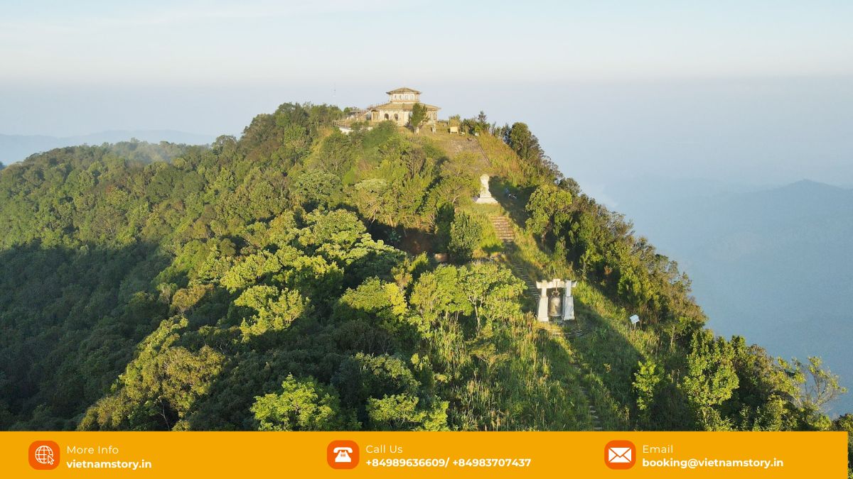
Known as the “roof of Y Ty,” Lao Than Mountain reaches 2,860 meters. It’s often hailed as a great option for first-time multi-day trekkers due to its moderate difficulty compared to other high peaks. The climb offers stunning panoramic views over terraced rice fields and is particularly famous for spectacular sunrises seen from the summit, often above a sea of clouds. It’s considered one of the best Vietnamese mountains for accessible trekking adventures.
- Location: Bat Xat District, Lao Cai Province (near Y Ty).
- Height: 2,860m.
- Access: Moderate trek, suitable for beginners to multi-day hiking.
- Best time to visit: October to April.
- Highlights: Accessible trek, stunning sunrises, cloud sea views, terraced rice fields.
- Entry Fee: Generally free, guide recommended.
5. Ky Quan San (Bach Moc Luong Tu) (Lao Cai & Lai Chau Provinces): Challenging Beauty
Straddling Lai Chau and Lao Cai provinces, Ky Quan San (also known as Bach Moc Luong Tu) stands at 3,046 meters (9,993 feet). It’s one of the highest and most challenging Vietnamese mountains to climb, attracting seasoned trekkers. The trails wind through dense forests, past waterfalls, and across meadows, offering diverse and dramatic scenery. Like Ta Xua and Lao Than, it’s renowned for breathtaking “sea of clouds” views, making the strenuous multi-day trek incredibly rewarding.
- Location: Border of Lao Cai and Lai Chau Provinces.
- Height: 3,046m.
- Access: Challenging multi-day trek.
- Best time to visit: March to May.
- Highlights: High altitude challenge, stunning cloud seas, diverse ecosystems (forests, waterfalls).
- Entry Fee: Generally free, guide essential.

Central Vietnam: Coastal Peaks and National Parks
6. Marble Mountains (Ngu Hanh Son) (Da Nang)
Just a short drive from Da Nang city, the Marble Mountains are a cluster of five limestone and marble hills named after the five elements (Kim – Metal, Thuy – Water, Moc – Wood, Hoa – Fire, Tho – Earth). These unique Vietnamese mountains are famous not just for their geology but for the intricate network of caves, tunnels, and Buddhist sanctuaries hidden within. Visitors can climb the steps (or take an elevator up Mount Thuy) to explore pagodas, grottos, and enjoy stunning views of the coastline and Da Nang city. Their accessibility and cultural significance make them a must-visit.
- Location: About 8-9 km southeast of Da Nang city center.
- Height: Relatively low peaks, highest (Thuy Son) around 100m+.
- Access: Easy, stairs and elevator available for Mount Thuy.
- Best time to visit: March to August (dry season).
- Highlights: Five elemental hills, caves, pagodas, stone sculptures, coastal views, easy access.
- Entry Fee: Approx. 40,000 VND (around 100 INR) for Mount Thuy, additional fees for elevator/specific caves may apply.
- How to get there: Easily reached by motorbike, car, or bus from Da Nang.
7. Bach Ma Mountain (Thua Thien Hue Province): Biodiversity Hotspot
Located within Bach Ma National Park near Hue, Bach Ma Mountain rises to 1,450 meters (4,757 feet). This area, part of the Annamite Range, is renowned for its cool climate, lush rainforests, stunning waterfalls (like Do Quyen Waterfall), and exceptional biodiversity, making it a paradise for nature lovers and birdwatchers. Hiking trails wind through the park, offering chances to spot diverse flora and fauna. Remnants of French colonial villas add a historical touch. It’s one of the most ecologically important Vietnamese mountains.
- Location: Bach Ma National Park, Phu Loc District, Thua Thien Hue Province (accessible from Hue or Da Nang).
- Height: 1,450m.
- Access: Road access into the park, various hiking trails.
- Best time to visit: February to August (dry season).
- Highlights: Rich biodiversity, waterfalls, birdwatching, hiking trails, cool climate, French colonial remnants.
- Entry Fee: Park entrance fee approx. 60,000 VND (around 150-300 INR), plus potential transport fees within the park.
- How to get there: Private car or tour from Hue (approx. 40-60km) or Da Nang (approx. 60km).
8. Son Tra Peninsula (Monkey Mountain) (Da Nang)
Jutting out into the sea just north of Da Nang’s beaches, Son Tra Peninsula, often called Monkey Mountain, reaches a height of 693 meters (2,274 feet). While not as high as others, this verdant mountain offers spectacular panoramic views of Da Nang city, the bay, surrounding beaches (like Bai But, Bai Bac), and the distant Cham Islands. It’s a vital habitat for the endangered red-shanked douc langur, a beautiful primate. The iconic Linh Ung Pagoda with its giant Lady Buddha statue is a major landmark. Winding roads make it accessible by motorbike or car, offering a peaceful escape close to the city.
- Location: Son Tra Peninsula, northeast of Da Nang city center.
- Height: 693m.
- Access: Easy via winding paved roads (motorbike or car recommended).
- Best time to visit: January to August (dry season).
- Highlights: Panoramic city and sea views, Linh Ung Pagoda, chance to see red-shanked douc langurs, secluded beaches.
- Entry Fee: Free.
- How to get there: Short drive (approx. 30-35 minutes) from Da Nang center.
9. Ba Na Hills (Da Nang)
While famous as a resort and theme park complex, Ba Na Hills is situated high on Nui Chua Mountain at an altitude of 1,489 meters near Da Nang. It’s known for its year-round cool climate, often experiencing “four seasons in a single day.” Access is primarily via one of the world’s most impressive cable car systems, offering stunning views during the ascent. Besides the famous Golden Bridge (held by giant hands), visitors find replicas of French villages, gardens, pagodas, and entertainment facilities. It blends natural mountain scenery with man-made attractions, making it one of the most unique tourist-focused Vietnamese mountains.
- Location: Nui Chua Mountain, about 20-25 km west of Da Nang downtown.
- Height: 1,489m.
- Access: Primarily via extensive cable car system.
- Highlights: Golden Bridge, French Village replica, amusement park, stunning views, cool climate, impressive cable car ride.
- Entry Fee: Significant fee covering cable car and most attractions (check current prices).
- How to get there: Taxi, motorbike, private car, or shuttle bus from Da Nang.
Southern & Central Highlands: Plateaus and Retreats
10. Langbiang Mountain (Da Lat, Lam Dong Province)
A prominent landmark overlooking the charming city of Da Lat, Langbiang Mountain consists of three peaks, with the highest reaching 2,167 meters (or 2,287m depending on source, approx. 7,110 feet). Often called the “roof of Dalat,” it offers marvelous views of the city, surrounding pine forests, lakes, and rivers. Known for its pleasant cool climate and association with a local K’Ho ethnic minority legend, Langbiang is a popular destination. Visitors can reach lower peaks via shared jeeps on a paved road or challenge themselves with hiking trails to higher, less-visited summits. The sunset views can be particularly enchanting.
- Location: Lac Duong District, about 12 km north of Da Lat city center.
- Height: Main tourist peak lower, highest peak 2,167m / 2,287m.
- Access: Jeep service to lower peak, hiking trails to higher peaks.
- Best time to visit: December to April (dry season).
- Highlights: Panoramic views of Da Lat, pine forests, cultural legend, jeep rides, hiking opportunities, sunset views.
- Entry Fee: Entrance fee approx. 30,000-50,000 VND (around 100-300 INR), plus jeep fee if used.
- How to get there: Easy car drive or motorbike ride from Da Lat.

11. Black Virgin Mountain (Nui Ba Den) (Tay Ninh Province)
Steeped in legend and religious significance, Black Virgin Mountain (Nui Ba Den) is the highest peak in southeastern Vietnam at 986 meters. Located near Tay Ninh city (famous for the Cao Dai Temple), it’s a major pilgrimage site with numerous pagodas and temples dotting its slopes and summit. A modern cable car system provides easy access for pilgrims and tourists, while hiking trails offer a more strenuous ascent. The panoramic views over the flat plains of Tay Ninh province are expansive. It’s considered one of the most important spiritual Vietnamese mountains in the south.
- Location: About 11 km northeast of Tay Ninh city center.
- Height: 986m.
- Access: Cable car or hiking trails.
- Best time to visit: November to March (dry season).
- Highlights: Major pilgrimage site, numerous pagodas, modern cable car, panoramic views over plains.
- Entry Fee: Entrance fee and separate cable car fee (approx. 250 INR for round trip cable car, check current prices).
12. Mua Mountain (Mua Caves) (Ninh Binh Province)
While technically a smaller peak, Mua Mountain in Ninh Binh offers one of the most iconic and photographed views in all of Vietnam. It’s not primarily known for its height but for the breathtaking panorama from its summit. After climbing around 500 stone steps up a winding path dotted with rocky outcrops, visitors are rewarded with stunning vistas of the Ngo Dong River meandering through verdant rice paddies and towering limestone karsts – the landscape often called “Ha Long Bay on Land.” The Mua Caves complex at the base is also worth exploring. It’s a must-visit viewpoint among the accessible Vietnamese mountains.
- Location: Hoa Lu District, Ninh Binh Province (near Tam Coc).
- Height: Relatively low karst peak.
- Access: Climbing ~500 steps.
- Highlights: Iconic panoramic view of Tam Coc landscape (karsts, river, rice fields), photography spot.
- Entry Fee: Entrance fee for the Mua Caves complex (approx. 100,000 VND).
- How to get there: Easy motorbike or taxi ride from Ninh Binh city or Tam Coc. Can be part of Ninh Binh tours from Hanoi.
13. Ba Vi Mountain Range (Near Hanoi)
Situated about 50-60 km west of Hanoi, the Ba Vi Mountain Range offers a refreshing escape from the capital’s bustle. It consists of three main summits (Dinh Vua, Tan Vien, Ngoc Hoa), with the highest reaching 1,296 meters. The range is home to Ba Vi National Park, known for its cool climate, lush forests, diverse flora and fauna (over 1,200 plant species, 60+ mammal species), and natural streams. Visitors can enjoy hiking trails leading to temples, viewpoints, and old French colonial ruins amidst a mysterious, often cloudy atmosphere. Its proximity to Hanoi makes it a popular day trip or weekend getaway.
- Location: Ba Vi District, about 50-60 km west of Hanoi center.
- Height: Highest peak 1,296m.
- Access: Road access to the National Park, hiking trails within.
- Best time to visit: March to November (avoiding coldest winter months).
- Highlights: Ba Vi National Park, cool climate, rich biodiversity, hiking trails, temples, close proximity to Hanoi.
- Entry Fee: Park entrance fee approx. 60,000 VND (around 150-200 INR).
- How to get there: Rent a private car or motorbike from Hanoi directly to the park.
Trekking and Tourism in Vietnamese Mountains: Adventure Awaits
The diverse Vietnamese mountains offer a playground for outdoor enthusiasts. Trekking and hiking are prime activities, with options ranging from gentle day walks (like at Ba Vi or Mua Caves) to challenging multi-day expeditions requiring fitness and preparation (Fansipan trek, Pu Si Lung, Ky Quan San). Beyond trekking, opportunities abound for mountain biking, rock climbing (in specific areas), camping under starry skies, birdwatching (especially in national parks like Bach Ma and Ba Vi), and photography.
Cultural tourism is also significant, with many treks passing through or near villages of ethnic minority groups, offering insights into their traditional lifestyles. Infrastructure varies greatly: popular areas like Sapa (for Fansipan), Da Lat (for Langbiang), and Da Nang (for Ba Na, Marble, Son Tra) have well-developed facilities including hotels, restaurants, and transport options like cable cars. Remote peaks require more self-sufficiency and careful planning.
Practical Tips for Exploring Vietnamese Mountains:
- Best Time: Generally, the dry season (often October/November to April/May for the North, varying elsewhere) offers better trekking conditions and clearer views, but check specific regional climates.
- Permits: Required for certain remote areas (like Pu Si Lung) or national parks. Research in advance.
- Guides: Highly recommended, often mandatory, for challenging or remote treks. They provide safety, navigation, and cultural insights.
- Gear: Pack appropriately for the weather (layers are key), sturdy hiking shoes, rain gear, sun protection, water, snacks, and a basic first-aid kit.
- Fitness: Assess the trek difficulty honestly and ensure you have the necessary physical fitness, especially for high-altitude climbs. Acclimatize if needed.
- Responsible Tourism: Respect local cultures and environments. Stay on marked trails, pack out all trash, avoid disturbing wildlife, and support local communities by purchasing local goods or services where appropriate.
Cultural Significance of Vietnamese Mountains
Beyond their stunning natural beauty, Vietnamese mountains hold deep cultural significance. Many peaks are considered sacred sites by local ethnic communities, interwoven with myths, legends, and spiritual beliefs. These regions are home to a vibrant tapestry of ethnic minority groups (like Hmong, Dao, Tay, Nung, K’Ho, Ede), each with unique languages, customs, and traditional attire. Their way of life is often intimately connected to the mountain environment, beautifully exemplified by the iconic terraced rice fields sculpted into the hillsides – a testament to generations of agricultural ingenuity and a breathtaking sight for visitors.
READ MORE: A journey through the top natural wonders in Vietnam
Conservation Challenges: Protecting a Fragile Heritage
Vietnam’s majestic mountains face significant conservation challenges. Deforestation due to logging and agricultural expansion, the illegal wildlife trade, and the impacts of climate change threaten their fragile ecosystems and rich biodiversity. Balancing the economic benefits of tourism development with the need to protect these natural landscapes and the unique cultures they sustain remains a critical task.
Conclusion: Embrace the Heights of Vietnam
The Vietnamese mountains are a national treasure, offering an incredible range of experiences for every traveller, especially those from India seeking adventure, natural beauty, and cultural immersion. From the challenging summit of Fansipan, the “Roof of Indochina,” accessible by trek or cable car, to the mystical cloud seas of Ta Xua, the sacred caves of the Marble Mountains, and the refreshing retreats near Hanoi and Da Lat, there’s a mountain adventure waiting for you.
By planning thoughtfully, respecting local cultures and environments, and perhaps joining a well-organized tour, you can safely explore these majestic peaks and create unforgettable memories. Whether you seek adrenaline-pumping treks or serene scenic views, Vietnam’s mountains are ready to inspire awe and wonder. Add these incredible peaks to your Vietnam travel list and prepare to be amazed.
Recommended Tours


Hanoi - Halong - Sung Sot - Titop - Luon Cave - Hanoi
- Duration
- 1 day
- Travel insurance
- Included


Hanoi - Lan Ha Bay - Cat Ba - Hanoi
- Hotel options
- 3-star or 4-star
- Travel insurance
- Included

Hanoi - Halong - Sung Sot - Titop - Luon Cave - Hanoi
- Hotel options
- 3-star or 4-star
- Travel insurance
- Included
Hanoi - Bai Tu Long - Thien Canh Son - Hanoi
- Hotel options
- 3-star or 4-star
- Travel insurance
- Included


Ho Chi Minh - Cu chi tunnels - Mekong Delta - Mui Ne - Jeep tour while sand Dune - Red Sand Dune - Danang - Bana hill- Golden Bridge - Marble mountain - Monkey Mountain
- Hotel options
- 3-star or 4-star
- Travel insurance
- Included


Hanoi - Lan Ha Bay - Dark And Bright Cave - Hanoi
- Hotel options
- 3-star or 4-star
- Travel insurance
- Included