
Navigating the 1,969 limestone karsts of our famous bay requires much more than a simple paper guide. The geography of this region reached a new milestone. Following a massive UNESCO expansion, Ha Long Bay and the Cat Ba Archipelago have officially merged into a single, inter-provincial conservation zone spanning over 65,650 hectares. This means the Halong map you might have seen a few years ago is now much larger and more diverse. At Vietnamstory, we specialize in making this vast landscape accessible. We provide our Indian guests with custom “Storytelling Maps” that don’t just show where to go, but highlight the most auspicious and photo-worthy spots for your journey, including the lates filming locations. Whether you are seeking a luxury retreat or a family adventure, our curated Halong Bay Cruise offerings ensure you are always at the right place at the right time.

Regional location and the “Three-Bay” complex on the Halong map
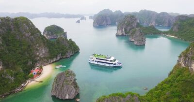
To truly master the Halong map, you must first realize that “Ha Long” is actually a system of three distinct bays, each offering a unique “vibe” and level of tourist activity. Located in Quảng Ninh Province, approximately 170km east of Hanoi, this maritime maze is far more complex than a single body of water.
SWhere exactly is Ha Long located and how is it divided? It sits in the northeast of Vietnam, the Halong map is categorized into three zones: the iconic Central Ha Long Bay, the southwestern Lan Ha Bay (the gateway to Cat Ba), and the northeastern Bai Tu Long Bay (the tranquil “hidden gem”). When you look at a modern Halong map, you will see these three sectors color-coded to help travelers choose their perfect route. Here is a breakdown of what each area offers:
- Central Ha Long Bay: This is the “Main Stage.” It holds the highest density of world-famous caves like Sung Sot (Surprise Cave) and the iconic Ti Top Island. If it is your first time in Vietnam, this is the heart of the UNESCO core.
- Lan Ha Bay (Southwest): Technically managed by the Hai Phong province but geographically part of the same karst system, this area is the gateway to Cat Ba Island. It is famous for having more swimmable, natural white-sand beaches like Ba Trai Dao and is the only place to spot the critically endangered Cat Ba Langur.
- Bai Tu Long Bay (Northeast): For our guests who prefer “Quiet Luxury” and want to avoid the crowds, this is the place. It features pristine spots like Thien Canh Son Cave and the untouched beaches of Cong Dam.
Understanding these three “arms” of the bay is the first step in deciding which cruise itinerary fits your personal story.
Choosing your starting point

The “starting line” for your adventure is just as important as the destination. Choosing the wrong harbor can result in a long taxi ride across the city, so knowing the exact “pin” on your Halong map is essential for catching your boat on time. Which port should you navigate to for your cruise? The Halong map features two primary gateways: Tuan Chau International Marina (the western luxury hub for overnight stays) and the Ha Long International Cruise Port in Bai Chay (the central hub for day trips and massive ocean liners).
To help you distinguish between these two modern gateways, we have prepared a comparison of their features and accessibility. Please refer to the following table to identify which port matches your booking:
| Feature | Tuan Chau Marina | Ha Long International (Bai Chay) |
| Location | Tuan Chau Island (15km from city) | Bai Chay Beach Ward (City Center) |
| Primary use | Luxury overnight cruises (Heritage, Paradise, Ambassador) | Day cruises and global super-luxury liners |
| Unique amenities | Electric seaplane terminal, golf course, private resorts | Duty-free shops, walking street access, Sun World proximity |
| Access | 45 min from Hanoi via Electric Seaplane | Walkable from major Bai Chay 5-star hotels |
As an “insider” tip, the Tuan Chau Marina has recently become the hub for the new Electric Seaplane service. If you want to bypass the 2-hour road trip from Hanoi, you can take a 45-minute flight and land directly on the water at the Tuan Chau port – this is undoubtedly the most spectacular way to start your journey!
READ MORE: An Insider’s Guide To Halong Harbour For Indian Travelers
Navigating the regulated itineraries
To protect the 500-million-year-old limestone formations and manage the “carrying capacity” of the heritage site, the Management Board has updated the Halong map of cruise routes. Every boat is assigned a specific path, and understanding these routes helps you know exactly which caves and islets you will see.

How do boats move through the water? The Halong map of cruise routes is divided into five numbered paths. Route 1 is the short, classic loop for seniors, Route 2 is the most popular path covering the “Big Hits” like Ti Top and Sung Sot; and Route 5 is the modern “Bridge Route” linking Ha Long to Cat Ba Island. When we plan a tour for our Indian guests, we look at the specific “flavor” of each route. Here are the three most popular routes you will find on your Halong map:
- Route 1 (The classic/short route): This usually starts from Tuan Chau or Bai Chay and visits Thien Cung Cave, Dau Go Cave, and the iconic Fighting Cock Islet. It typically takes 4 hours and is ideal for seniors or families with very young children who prefer shorter walking distances.
- Route 2 (The “big hits” route): This is the most famous itinerary. It includes the largest cave, Sung Sot (Surprise Cave), a climb to the Ti Top Island summit for that 360-degree panorama, and kayaking in Luon Cave lagoon. This is the gold standard for first-timers.
- Route 5 (The inter-provincial link): This is the New route. It links the Tuan Chau harbor directly to the Gia Luan Pier on Cat Ba Island. This is the best choice for travelers who want to combine a bay cruise with a jungle trek in the National Park.
Knowing your route number is vital because it determines which “icons” of the bay you will be able to photograph.
Vietnamstory signature
You don’t just want a map; you want a guide to the “Bollywood” spots, spiritual centers, and – most importantly – where to find a good masala chai or a Jain-friendly meal! What makes the Vietnam Story Halong map unique for Indian travelers?

We have customized our digital navigation to include these three specific “Indian-centric” layers on the Halong map:
- The “Silaa” Bollywood map: The high-budget Bollywood film Silaa, starring Sadia Khateeb, was filmed right here in Ha Long. Our guests often want to recreate those cinematic moments, so we provide the exact GPS pins for the limestone arches and beaches used in the film.
- Spiritual landmarks: For our travelers seeking a “Zen” connection, we highlight Yen Tu Mountain, located about 60km from the bay. A new “Forest Tourism” initiative has opened paths connecting the maritime beauty of the bay to these sacred mountain peaks, creating a perfect spiritual loop.
- The “Indian kitchen” cluster: We know that after a few days, you might crave a taste of home. We map the Cai Dam area in Bai Chay, which has become the go-to spot for authentic Indian kitchens like The One Indian and Apna.
Having these specific locations on your Halong map ensures that your cultural and dietary needs are met without any stress or confusion.
READ MORE: A Guide To The Best Things To Do In Halong Bay For Indian Travelers
Pro-tips for Indian travelers
Technology has changed how we use the Halong map, but local knowledge still holds the key to the most magical moments. How can you use technology and “insider” secrets to enhance your Halong map experience? ITravelers can use AR (Augmented Reality) apps to identify karsts, find the specific islet featured on the 200,000 VND note, and – crucially – download offline maps to prepare for signal drops between the high cliffs. Here are four “expert” tips for your visit:
- Interactive AR maps: Most premium cruises now provide a QR code at check-in. This opens an AR map on your phone, when you point your camera at a limestone karst, the screen identifies it by name and tells you its “legend.” It makes the Halong map come to life!
- The “200,000 VND” pin: One of our favorite activities for guests is the “Currency Match.” Locate Dinh Huong Islet (Incense Burner) on your map. It is the exact islet featured on the back of the 200,000 VND note. It makes for a wonderful “islet-to-bill” photo!
- Offline navigation is mandatory: This is a vital tip. Because the limestone walls are 50 – 100 meters high, 4G and 5G signals often drop to zero once you are deep in the bay. Always download the “Ha Long – Cat Ba Heritage Zone” on Google Maps for offline use before you leave the pier.
- Vung Oan Island: This is a “rare map find” near the Bai Tho Bridge. It was a primary filming location for the 1991 classic film Indochine. It has become a favorite “secret” spot for photography buffs looking for a vantage point that isn’t on the standard tourist routes.
Conclusion
The Halong map is a living document, constantly changing with new discoveries and improved conservation efforts. Whether you are following the Bollywood trail, seeking a spiritual connection at Yen Tu, or simply looking for the best sunset on Route 2, the map is your key to unlocking the secrets of the Mother Dragon.
At Vietnamstory, we are here to help you navigate every turn. We understand the specific needs of our Indian travelers and are committed to ensuring your journey through the 1,969 karsts is as seamless as it is spectacular. We look forward to seeing you on the water in 2026!
Top Halong Bay Tours You’ll Love


Vietnam Highlights 7 Days: From Hanoi to Phu Quoc
Hanoi - Halong bay - Da Nang - Hoi an ancient town - Phu Quoc


8 Days Vietnam Journey: Culture, Heritage & Natural Wonders


Hanoi - Halong - Sung Sot - Titop - Luon Cave - Hanoi


Serenity Grandeur Cat ba cruise
Lan Ha Bay - Cat Ba - Cai Beo Floating Village - Viet Hai Village - Turtle Island - Tai Keo Cave


Hanoi - Lan Ha Bay - Dark And Bright Cave - Hanoi